Quick Guide – Community Map
Last modified on 11th April, 2024
Have you senn on the Community homepage or in the Communities area the map displayed there and wondered what it’s actually all about? Then we will shed some light into the darkness below.
What is the Community Map and what does it include?
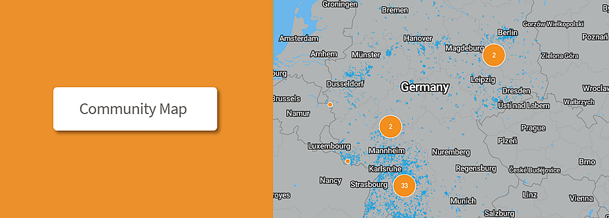
The Community Map serves as an informative basis that shows you where in your area you can expect LoRaWAN® coverage through gateways from other B.One Community members.
It consists of two superimposed layers:
The blue colored areas indicate the expected coverage of the ZENNER Connect LoRaWAN® network in the outdoor area. The range of each gateway was calculated with simulation parameters adapted to the respective installation situation using the “Irregular Terrain Model” and visualized in superimposition with all surrounding gateways. The simulation result only serves as a rough guide as to where it can be expected that connectivity to the ZENNER Connect LoRaWAN® network can be established with a compatible device. The actual range may vary – there is no entitlement to LoRaWAN® coverage in the areas shown.
The dots colored orange are gateways provided by community members, which further expand the network that can be used collectively. In the lower zoom levels, these are combined into clusters, specifying the number of gateways contained in each case. By clicking on an individual gateway, additional meta information such as the gateway type is displayed.
Which gateways are shown on the map and what do you have to do for this?
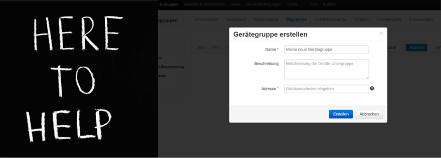
The map shows the IoT gateways of community members that are integrated into the ZENNER Connect LoRaWAN® network, were purchased via the ZENNER Shop I IoT Sensors & Solutions and whose position and other meta information are stored in the ZENNER Datahub gateway management system (GMS). It doesn’t matter whether it’s a ZENNER IoT GatewayPLUS Indoor, Outdoor or SMART. To display your gateway on the map, simply enter this information for your gateway in the platform as described in our “Quick Guide ZENNER Datahub”. We update the map regularly, so all community members can stay up to date with the new devices that have been added and see how our shareable LoRaWAN® network continues to grow!
If you access the map from the homepage , you’ll see all of our community’s gateways on the map.
In the Communities area, you can search for communities using the search field at the bottom right of the map or click on the desired community directly in the selection listed below. Within a community, all gateways belonging to this community are then displayed on the map.
How accurate/precise is the gateway location shown on the map?
The maximum possible zoom factor on the map when looking at an individual gateway is deliberately kept so large that neither the exact building nor the exact address can be seen by other users. Of course, the coordinates visible in the ZENNER Datahub are not displayed here either.
Do you have further questions about the Community Map? Then feel free to put them in the comments.
Responses